


Seljuk Alanya from the Castle to the Harbour
Sign in to like and rate
The Alanya peninsula is a rocky headland reaching into the Mediterranean and one of the most complete witnesses to Seljuk seafaring in Anatolia. Known as Kalonoros in the Byzantine period, the town surrendered in 1221 to the Anatolian Seljuk Sultan Alaeddin Keykubad I, and its name was changed to Alaiye after its new conqueror. The Seljuk sultans began to spend their winters here; within a few years the walls running from the summit of the peninsula down to the harbour, the Kızıl Kule guarding the harbour and the dockyard where ships were built had all risen. The inscription of the Kızıl Kule bears the date 1226, while sources give 1227 or 1228 for the dockyard. Alaeddin Keykubad, who also had a dockyard built at Sinop, came to be called the "Sultan of the Two Seas" because of these works.
The route crosses the peninsula from one end to the other and moves on without doubling back. The first stop is Damlataş Cave on the western shore of the peninsula. The cave was discovered in 1948 while stone was being quarried for the construction of the harbour, so the story of the harbour you will reach at the end of the day already begins at the first stop. The cable car leaving from the station near the cave carries you up to the Ehmedek section of the castle and spares you the longest climb. From there you walk up to the İçkale and look out from the summit, about 250 metres above the sea, over the western shore and towards the Taurus Mountains. On the way back you descend the eastern slope of the peninsula and reach the Kızıl Kule, where the walls begin. The last stop is the dockyard, reached on foot from the tower along the walls. The day thus flows in a line from the summit down to sea level, and the only climbing is left to the cable car.
The castle section is the longest and most tiring part of the route. The walls run for 6.5 kilometres, and inside them buildings from the Seljuk, Ottoman and earlier periods are scattered over a wide area; rather than trying to see them all, focus on the İçkale, the surroundings of the Süleymaniye Mosque and the viewpoints on the walls. The paths are paved with stone in places and sloping, so keep away from rocky edges; wear closed, non-slip shoes and take water and a hat. Hisariçi, inside the walls, is still a lived-in neighbourhood, so do not enter the doorways and gardens of the houses.
At the Kızıl Kule the upper floors are reached by a stone staircase of 85 steps, so take your knees into account. For entry conditions, opening hours and fees, check the up-to-date information on the Ministry of Culture and Tourism's muze.gov.tr site, and for the cave and the cable car on the official sites of their operators. Although the distance you walk during the day looks short, the ups and downs inside the castle take time; it is best to set aside a full day and not to hurry.
Sources
- Kültür Portalı, Alanya Kalesi, https://www.kulturportali.gov.tr/turkiye/antalya/gezilecekyer/alanya-kalesi
- Kültür Portalı, Kızılkule, https://www.kulturportali.gov.tr/turkiye/antalya/gezilecekyer/kizilkule-etnografya-muzesi
- Kültür Portalı, Alanya Tersanesi ve Kızıl Kule, https://kulturportali.gov.tr/portal/alanya-tersanesi-ve-kizil-kule
- Kültür Portalı, Damlataş Mağarası, https://www.kulturportali.gov.tr/turkiye/antalya/gezilecekyer/damlatas-magarasi
- Antalya İl Kültür ve Turizm Müdürlüğü, Alanya Kalesi, https://antalya.ktb.gov.tr/TR-310806/alanya-kalesi.html
- Kültür ve Turizm Bakanlığı Müze Kart, Alanya Kalesi, https://muze.gov.tr/muze-detay?SectionId=ALN01&DistId=ALN
- Alanya Belediyesi, Süleymaniye Camisi, https://www.alanya.bel.tr/S/511/Suleymaniye-Camisi
- Alanya Belediyesi, Damlataş Mağarası, https://www.alanya.bel.tr/S/567/Damlatas-Magarasi
- TDV İslam Ansiklopedisi, Alanya, https://islamansiklopedisi.org.tr/alanya
- Wikipedia, Alanya Tersanesi ve Tophane, https://tr.wikipedia.org/wiki/Alanya_Tersanesi_ve_Tophane
- Wikipedia, Kızılkule, https://tr.wikipedia.org/wiki/Kızılkule
- Wikipedia, Alanya Teleferik, https://tr.wikipedia.org/wiki/Alanya_Teleferik
- Wikipedia, Damlataş Mağarası, https://tr.wikipedia.org/wiki/Damlataş_Mağarası
- Wikipedia, Red Tower (Alanya), https://en.wikipedia.org/wiki/Red_Tower_(Alanya)
- Wikipedia, Alanya Castle, https://en.wikipedia.org/wiki/Alanya_Castle
- Türkiye Turizm Ansiklopedisi, Alanya Kalesi, https://turkiyeturizmansiklopedisi.com/alanya-kalesi
Route Stops
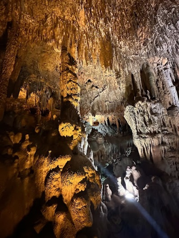
Damlataş Mağarası
Begin the day on the western shore of the peninsula, at the cave entrance on Damlataş Caddesi. The front of the cave opens onto a beach, and a small bazaar has grown up around the entrance. Stop here for a moment and look up: you are right at the foot of the rock mass on which the Seljuk walls stand, and in a few hours you will be looking down on this shore from the summit.
The story of the cave ties into the rest of the route. In 1948, while a quarry was being opened here for stone to be used in harbour construction, a blast exposed the hollow inside the rock. Starting a route that ends at the Seljuk harbour with a cave found while stone was being sought for a harbour is therefore a fitting opening. Damlataş is known as the first cave in Turkey to be opened to tourism. The Kültür Portalı notes that entry is charged; check the current fee and hours on the official site of Alanya Municipality.
Once inside, you first walk along a passage of about fifty metres. The passage brings you to a cylindrical hollow whose height reaches fifteen metres. The cave takes its name from the water that drips ceaselessly from the stalactites on its ceiling. Stand still for a while and watch how the drops gather at the tips of the stalactites. The stalactites and stalagmites are thought to have formed between 20,000 and 15,000 BC. Look especially at the points where the stalactites coming down from the ceiling and the stalagmites rising from the floor draw close to each other. Do not touch the formations, and do not climb onto railings or rocks for a photograph.
The air in the cave does not change between summer and winter; the temperature is 22 degrees and the humidity around 95 per cent. Coming in from the summer heat outside, this air feels cool, while in winter it feels mild. Because the humidity is high, glasses and camera lenses may fog up as soon as you enter; wait a few minutes for them to warm up. The dripping water can leave the floor wet in places, so go in wearing non-slip shoes rather than beach sandals. Wet stone surfaces make flash light glare; if possible shoot without flash and find a spot where you can hold your camera steady. The cave is not large; when visitors crowd in you may have to wait in the narrow passage, so arriving early makes things easier.
When you come out, walk along the shore to the cable car station beside Kleopatra Beach. The cable car line is about 900 metres long and ends at the Ehmedek section of the castle. Look down as the cabin rises, because the line passes over the cave you have just left and over Kleopatra Beach. It is also possible to walk up to the castle, but since the walk to the İçkale takes about an hour, it is wiser to save your energy for the tour inside the castle. For the cable car's operating hours and fare, check the operator's official site.
Source: Kültür Portalı; Alanya Belediyesi; Wikipedia.
The Damlataş Cave, located in the Alanya district of Antalya, is a fascinating natural formation with its stalactites and stalagmites. Discovered in 1948, this cave is notable for its limestone formations that have developed over millions of years and its high humidity level.
The air inside the cave has a 90% humidity level and is said to be beneficial for asthma patients. The temperature inside remains stable at around 22-23°C throughout the year. The cave, illuminated with colorful lights, offers a mystical atmosphere to its visitors.
With its proximity to Alanya Castle, the Damlataş Cave is easily accessible and is an important site for nature and health tourism. You must visit to discover its unique beauty and breathe in its healing air! 🏞️💎✨
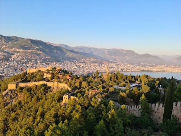
A Historical Heritage Dominating the Mediterranean: Alanya Castle
When you step off the cable car at Ehmedek, you are inside one of the sections of the castle separated from each other by walls. Alanya Castle is regarded as one of the best preserved medieval castles still standing in Anatolia, and it is on the UNESCO World Heritage Tentative List. Traces of settlement on the peninsula go back to the 3rd century BC; the monumental castle you see today was built by the Seljuks after 1221 on top of older Byzantine and Roman walls. The walls run for 6.5 kilometres and are reinforced with 140 towers. Do not try to walk their whole length; divide your two and a half hours here into three parts: the buildings of the middle castle, the İçkale and the descent down the eastern slope.
Before climbing to the İçkale, call in at the Süleymaniye Mosque, also known as the Orta Hisar Mosque. According to Alanya Municipality, the building was first commissioned by Alaeddin Keykubad I in the first half of the 13th century. After being destroyed by lightning, the mosque was rebuilt in the time of Süleyman the Magnificent using the old materials; its present plan and dome form date it to the 16th century. First look at the domes from outside: the square prayer hall is covered by a single hemispherical dome, while the late comers' portico is roofed with three small domes. The domes are of brick and the walls partly of brick and partly of dressed stone, and the use of the two materials together is easy to pick out on the wall surface. The minaret was added at the northwest corner of the prayer hall, and opposite the northeast corner there is a barrel-vaulted cistern with a covered ablution area beside it. If you go inside, take off your shoes, wear clothing that covers shoulders and knees, keep quiet and during prayer times be content with looking from outside. In the middle castle you can also see the trading building known as the bedesten and the mescit and tomb of Akşebe Sultan, dated 1230.
The roughly 400 cisterns scattered all over the castle show how precious water was on this rocky headland. If you come across the mouth of a cistern beside the path, do not lean over into it. Then climb up to the İçkale. The İçkale was built at the highest point, on the western corner of the peninsula, and stands some 250 metres above the sea. It can be toured like an open-air museum where remains from the Byzantine, Seljuk and Ottoman periods stand side by side. The remains of the palace of Alaeddin Keykubad are also in the İçkale. For entry to the İçkale, opening hours and fees, check the up-to-date information on muze.gov.tr.
At the summit, turn west first; the Damlataş shore you explored in the morning stretches out below, and the Taurus Mountains rise in the background. You will see that after the İçkale the walls run out to a steep crag called Adam Atacağı; according to an old story, the place takes this name from prisoners being thrown down from here. Be careful at the cliff edges and do not climb onto the walls for a photograph. From here the walls descend to Cilvarda Burnu and to the Arap Evliyası and Esat towers, then pass the Tophane and the Tersane and run as far as the Kızıl Kule. For the rest of the day you will follow the last part of this line from below, at the water's edge.
The castle's later history can also be read in these buildings: the Karamanids took the town in 1293, and in 1471 it passed to Ottoman rule with Gedik Ahmed Pasha. The lighthouse, counted among the buildings inside the castle, is dated 1720 and is one of the traces of this last period. Hisariçi, inside the walls, is still a lived-in neighbourhood; the houses behind the garden walls are not a museum but places where people live. For the descent, walk down the castle road towards the eastern slope of the peninsula; if you are tired you can take one of the minibuses that run along the road. The road brings you down to the bazaar and the harbour, in front of the Kızıl Kule where the walls begin.
Source: Kültür Portalı; Müze Kart (muze.gov.tr); Alanya Belediyesi; TDV İslam Ansiklopedisi.
Located in the Alanya district of Antalya, Alanya Castle is a magnificent defensive structure built on a 250-meter peninsula overlooking the Mediterranean. The castle, used since the Hellenistic period, was rebuilt by the Seljuk Sultan Alaaddin Keykubat in the 13th century, reaching its strongest form.
The castle is notable for its 6.5 kilometers of walls, 83 towers, and more than 140 bastions. Inside, there are structures such as Red Tower, Shipyard, Ehmedek, Suleymaniye Mosque, and Akşebe Sultan Mosque. The narrow stone streets within the castle offer visitors a historical atmosphere with houses dating back to the Ottoman period.
Alanya Castle, which has a magnificent view of the Mediterranean, offers a unique sight at sunset.
Red Tower.
When you come down from the castle and reach the harbour, do not go straight into the tower; first look at it as a whole from the quay. The Kızıl Kule is an octagonal building 33 metres high and 29 metres in diameter. Its lower part is built of stone and its upper part of the red brick that gives the tower its name; you can easily pick out from the quay the line where the two materials meet. The castle walls begin here, so you are standing in front of the first link of the line you followed from the summit in the morning. The tower is known as the symbol of Alanya, and between 1992 and 2005 it appeared on the reverse of the 250,000 lira banknote.
Look at the inscription on the entrance facade. The inscription records that the tower was commissioned from Ebu Ali of Aleppo in 1226 by the Seljuk Sultan Alaeddin Keykubad. The tower was both a defensive and an observation structure: it was built to protect the harbour where trade took place and to prevent attacks on the castle from the landward side. Today the entrance and first floor are arranged as the Ethnography Museum, and the tower has been open to visitors since 1979. Go round the museum section without hurrying, then get ready to climb. For entry conditions and hours, check the up-to-date information on muze.gov.tr.
Inside the tower there are five floors including the ground floor, and their plans differ from one another. There is a cistern in the middle of the tower; the sunlight it takes in from the top reaches down as far as the first floor. Stand around the cistern for a while to see how the light filters down through this vertical shaft. The upper floors are reached by a stone staircase of 85 steps; the steps are widely spaced, so climb without hurrying and watch your footing. On the way you will pass through vaulted corridors and come across arrow slits opened in the walls for defence. Look out through one of the slits and imagine how a sentry could watch the ships entering the harbour from here.
On the upper floors open terraces and a crenellated parapet await you. Looking out from here, the harbour lies below and behind you stretches the eastern slope of the castle you came down in the morning. From here, follow how the walls run south along the water's edge towards the Tersane; you will walk beside that line to the next stop. When taking photographs on the terrace, do not climb onto the battlements and hold your phone firmly. The tower also hosts events from time to time, such as painting exhibitions and classical music concerts; you can find out from the official announcements whether there is an event on the day of your visit.
When you come down, cross to the path that starts beside the tower and runs along the walls at the water's edge. The Tersane can be reached on foot along this path or by boat. Since the path runs at the water's edge, watch out for wet ground in rough weather.
Source: Kültür Portalı; Müze Kart (muze.gov.tr); Wikipedia.

Alanya Shipyard.
As you walk south from the Kızıl Kule along the path beside the walls, look up at the Tophane building standing above the path on a rock about 10 metres above the sea. This rectangular building of dressed stone was put up to protect the dockyard. A little further on, the walls come down to the sea and the five arched mouths of the dockyard open straight onto the water. Before going in, look at this facade as a whole from the shore: the seaward facade is 56.5 metres long and the building is 44 metres deep.
Sources give 1227 or 1228 as the year the dockyard was built; according to the Wikipedia article, construction began near the Kızıl Kule in 1228 and the building was completed within a year. The Kültür Portalı describes the Alanya Tersane as the only Seljuk dockyard to have survived intact to the present day. Remember that Alaeddin Keykubad also had a dockyard built at Sinop on the Black Sea, and that a trade route furnished with caravanserais was established between the two harbours. Alanya was the Mediterranean end of this route, and one of the two buildings that earned the sultan the title "Sultan of the Two Seas" is now in front of you. The TDV İslam Ansiklopedisi relates that in the Ottoman period the harbour of Alaiye was spoken of as large enough to hold two thousand ships.
Look carefully at the inscription at the entrance; it bears the sultan's emblem and is decorated with rosettes. Inside, five vaulted bays stretch side by side. From the seaward end of each bay, watch how the light falling on the stone fades as it goes deeper in. On one side of the dockyard there is a small mescit and on the other a guardroom; look for both at the edges of the bays. In one of the bays there is an old well whose mouth is blocked today. Today the building serves as the Ship and Maritime Museum, so as you walk between the bays, give some time to the pieces on display as well. For entry conditions, check the up-to-date information on muze.gov.tr.
Take the last photograph of the route from the water's edge, turning towards the Kızıl Kule. Seen from here, the line of the walls running along the shore towards the Kızıl Kule comes together in a single frame. The last links of the walls you followed from the summit in the morning are now right in front of you, and since the point where the day began you have walked from one end of the peninsula to the other. The stones near the shore can be slippery because of the waves; do not go too close to the water.
To return, walk back along the same path to the Kızıl Kule and the harbour, or choose to go back by boat. The area around the harbour connects with the town centre, and from there you can easily get back to where you are staying by city bus and minibus. As you end the day, do not forget to watch once more from the harbour the colour the castle walls take on in the evening light.
Source: Kültür Portalı; Antalya İl Kültür ve Turizm Müdürlüğü; TDV İslam Ansiklopedisi; Wikipedia.
