


Keçiören's Hilltops, from Esertepe to the Republic Tower
Sign in to like and rate
People who live in Ankara usually know the city from below, from the crowds of Kızılay or the slopes of Ulus. Keçiören, by contrast, is a residential district built on the hills to the north of the capital, and Wikipedia gives its average altitude above sea level as a little over a thousand metres. This route makes use of that height for a whole day: it looks at the city first from a hilltop, then from the foot of a tower, from beside the replica of a castle and from under a cable car line, and it ends the day in the museum of the institution that measures the sky.
Keçiören itself is part of this journey. According to Wikipedia, the district was a neighbourhood attached to Altındağ until a law passed in 1983 made it a district, and today it is the second most populous district of Ankara. The Çubuk stream divides the district into two parts; the whole route runs over the hills to the west of the stream.
The order runs from west to east and then from high ground to low. You begin the day in Muhammed Ali Esertepe Park, which rises among the apartment blocks of Etlik; the park, converted from a former military firing range, counts as one of the highest points of the city and opens a horizon to the south. From here you move east to Güçlükaya, the centre of the district. The Atatürk Republic Tower and the Estergon Turkish Culture Centre stand in the same neighbourhood, a few minutes' walk apart, and the upper station of the cable car is close by on the Tepebaşı side. Then you go down the slope to the Atatürk Botanical Garden and finally visit the museum on the campus of the Turkish State Meteorological Service in Kalaba.
The logic of this sequence is the view. At Esertepe you see the horizon in the morning light, at the tower you read the present-day skyline of the city, in the park beside Estergon you catch the same view from another angle, and in the Botanical Garden you come down from the heights into the shade of the trees. The Meteorology Museum is the natural close of the route, because there you see how the sky you have been watching all day is measured. Unlike the existing outing that uses Keçiören's stops for families with children around the themes of science and play, this route is built around height, horizon and reading the city.
You need a bus or a taxi between Esertepe and Güçlükaya; the remaining stops are linked on foot or by a single metro stop between the Belediye and Meteoroloji stations of the M4 line. There are plenty of slopes on the way, so wear comfortable shoes and take water with you.
Check three things before you set out. The Keçiören cable car was temporarily closed in April 2024; find out from Keçiören Municipality whether the line is running today, and if it is not, go down from the upper station to the Botanical Garden by metro. Ask the municipality as well about the current visiting status of the tower's observation terrace and upper floors. The Meteorology Museum can only be visited on weekdays, by appointment and with a guide.
Sources
- Ankara Büyükşehir Belediyesi, Esertepe'ye dev rekreasyon alanı, https://www.ankara.bel.tr/haberler/esertepe-ye-dev-rekreasyon-alani-3288
- Ankara Büyükşehir Belediyesi, Ankara'daki dev parka Muhammed Ali adı verildi, https://www.ankara.bel.tr/haberler/ankaradaki-dev-parka-muhammed-ali-adi-verildi-8821
- Wikipedia, Muhammed Ali Esertepe Parkı, https://tr.wikipedia.org/wiki/Muhammed_Ali_Esertepe_Parkı
- TRT Haber, Başkentteki Atatürk Cumhuriyet Kulesi açılıyor, https://www.trthaber.com/haber/turkiye/baskentteki-ataturk-cumhuriyet-kulesi-aciliyor-844574.html
- Keçiören Belediyesi, Atatürk Cumhuriyet Kulesi 100. Yıl Kütüphanesi, https://www.kecioren.bel.tr/ataturk_cumhuriyet_kulesi_100._yil_kutuphanesi-103-sosyal-tesis.html
- Wikipedia, Atatürk Cumhuriyet Kulesi, https://tr.wikipedia.org/wiki/Atatürk_Cumhuriyet_Kulesi
- Keçiören Belediyesi, Etnografya Müzesi, https://www.kecioren.bel.tr/kecioren_belediyesi_etnografya_muzesi-52-sosyal-tesis.html
- Wikipedia, Estergon Kalesi (Ankara), https://tr.wikipedia.org/wiki/Estergon_Kalesi_(Ankara)
- Wikipedia, Estergon Kalesi, https://tr.wikipedia.org/wiki/Estergon_Kalesi
- Yeni Ankara, Keçiören'de en güzel manzarayı izleyebileceğiniz park, https://www.yeniankara.com.tr/ankara/ankaranin-keciorende-en-guzel-manzarasini-izleyebileceginiz-park-bu-park-57289
- Keçiören Belediyesi, Atatürk Botanik Bahçesi, https://www.kecioren.bel.tr/ataturk_botanik_bahcesi-2-park.html
- Keçiören Belediyesi, Teleferik, https://www.kecioren.bel.tr/teleferik-42-sosyal-tesis.html
- Wikipedia, Keçiören Teleferiği, https://tr.wikipedia.org/wiki/Keçiören_Teleferiği
- Wikipedia, Keçiören Gondola, https://en.wikipedia.org/wiki/Keçiören_Gondola
- Meteoroloji Genel Müdürlüğü, Meteoroloji Müzesi, https://www.mgm.gov.tr/kurumsal/muze.aspx
- Wikipedia, Meteoroloji Müzesi, https://tr.wikipedia.org/wiki/Meteoroloji_Müzesi
- Keçiören Belediyesi, 2025 Mali Yılı Faaliyet Raporu, https://kecioren.bel.tr/faaliyet_raporlari_dosya_eki/2025_mali_yili_faaliyet_raporukecioren.bel.tr40.pdf
- Wikipedia, M4 (Ankara Metrosu), https://tr.wikipedia.org/wiki/M4_(Ankara_Metrosu)
- Wikipedia, Keçiören, https://tr.wikipedia.org/wiki/Keçiören
Route Stops

Muhammed Ali Esertepe Park.
Begin the route at Muhammed Ali Esertepe Park while the morning light is still soft. Ankara Metropolitan Municipality writes that the park lies between the Etlik and Esertepe neighbourhoods and can be entered from four separate points. Wikipedia gives the park's area as 18.3 hectares and its altitude as between 985 and 1055 metres. This height makes it one of the highest points of Ankara; the first of the horizons you will see on the rest of the route opens here. According to the municipality's description, the park contains four squares and four entrance gates, and they carry the names Ottoman, Seljuk, Hun and Republic of Türkiye. Make a note of which gate you came in by, because finding the same gate on the way out is not as easy on the wide slope as it seems. The park's history is also a story about height: according to Wikipedia, in the early years of the Republic the site was used by the army as an open-air firing range. As the city grew, its surroundings filled up with dense housing, and in 1970 the army stopped using the site for safety reasons. The site, which then stood empty for a long time, was taken over by Ankara Metropolitan Municipality in 2013, and the park opened to the public on 19 May 2015. The municipality's project announcement explains that the site stretches like a valley between Esertepe and Etlik and that it would be laid out on the model of the Dikmen Valley. The park took its present name in June 2016, by decision of the municipal council after the death of the boxer Muhammad Ali. To get around the slope easily, use the escalators and the three inclined lifts the municipality describes; they were also designed with disabled visitors in mind. First climb to the highest level of the park and turn south, towards the centre of the city. From here the bowl-shaped plain of Ankara and the hills that surround it read as a single whole. This upper level is also the best place to see from above the map of Türkiye laid out in groups of plants with illuminated edges. For photographs choose a wide angle, because the value of the park lies less in detail than in the breadth of the horizon. In the morning the sun is beside you rather than behind you, so the city skyline comes out more clearly. Sit for a few minutes in a corner away from the crowds and follow the horizon line from left to right; looking for the day's next stops in this view is the first game of the route. The slender tall tower rising to the east is the Atatürk Republic Tower, at whose foot you will soon be standing. Because the park is interwoven with the housing blocks around it, you will often meet local residents out for a morning walk; walk around without getting in their way. When you leave, exit the park through one of the entrances on the Etlik side. From here it is about three kilometres east to Güçlükaya, the centre of Keçiören. Instead of walking this stretch, use one of the buses that pass through Etlik or a taxi, and check the route information on the current EGO website.
Source: Ankara Büyükşehir Belediyesi, Muhammed Ali Esertepe Parkı; Wikipedia, Muhammed Ali Esertepe Parkı.
Atatürk Republic Tower.
When you reach Güçlükaya there is no need to look for the tower, because it is visible from every street in the neighbourhood. Keçiören Municipality gives the tower's address as Çağla Sokak in the Güçlükaya neighbourhood; the Belediye station of the M4 metro also serves this area. Do not go straight up to the tower at first; find a spot a few hundred metres away from which you can see its whole shaft. According to Wikipedia, the tower is built of reinforced concrete and is 197 metres tall. According to the Anadolu Agency report carried by TRT Haber, the tower was designed by Ragıp Buluç, who was also the architect of Atakule. Knowing that two towers in the Ankara skyline you looked at from Esertepe this morning came from the hand of the same architect is a good key to reading the city. According to the same report, the top of the tower is crowned with a Seljuk star; raise your head as you approach the shaft and look for that shape. Because the building is fitted with lighting and an LED screen system, it looks completely different from afar in the evening, so notice this on your way back as well. The construction of the tower stretched over more than twenty years. According to Wikipedia, the foundation was laid on 18 July 2003, and the building was originally due to be finished in April 2004. TRT Haber writes that construction was halted on the grounds that it exceeded the flight obstacle line; a long legal process followed. Wikipedia records that a new tender was held in 2020 and that the opening took place on 18 March 2024. According to the report, the tower contains sections such as an art gallery, a library, a sports hall, a wedding hall, a space terrace and a science centre. Of these, the one visitors can reach most easily today is the library. Keçiören Municipality's 2025 activity report states that the Atatürk Republic Tower 100th Year Public Library opened on 2 December 2024. According to the municipality's page, the library is on the minus first floor of the tower and has seating for 146 people, 130 in the adult section and 16 in the children's section. The collection numbers more than twenty thousand books, and you can become a member with your identity card. Sitting for a few minutes in this quiet hall in the middle of a busy day is one of the most unexpected breaks of the route. The municipal report notes that marriage services are also provided on the ground floor of the tower, so you may see crowds at the entrance at weekends. If you want to go up to the observation terrace and the upper floors, find out the current visiting status and conditions from Keçiören Municipality in advance. Even if you cannot go up to the terrace, looking up from the foot of the tower is enough to grasp the scale of the building. To get the whole tower into a photograph, use a wide-angle lens or step back a little. From here Estergon Castle is in the same neighbourhood, a few minutes' walk away; walk towards Fatih Caddesi.
Source: TRT Haber, Atatürk Cumhuriyet Kulesi; Keçiören Belediyesi, Cumhuriyet Kulesi 100. Yıl Kütüphanesi; Wikipedia, Atatürk Cumhuriyet Kulesi.

Estergon Castle Turkish Cultural Center.
Approach the Estergon Turkish Culture Centre from Fatih Caddesi in Güçlükaya; the municipality gives the museum's address as Fatih Caddesi in the Güçlükaya neighbourhood. Seeing this building after the tower is an interesting leap in time, because here you pass from a twenty-first-century tower to a copy of a sixteenth-century castle. According to Wikipedia, the centre opened on 29 May 2005 and was built as a replica of Esztergom Castle in Hungary. The original castle stands on the bank of the Danube, about sixty kilometres north-west of Budapest. As Wikipedia relates, the Ottomans first took that castle in 1543, were forced to surrender it in 1595, took it again in 1605, and the castle finally left Ottoman rule in 1683. The Estergon folk song, still sung today, grew out of the story of the defence of 1595. First walk once around the building and look at the outer facade. Wikipedia writes that construction of the building took six years and that its octagonal body was modelled on the Kızılkule of Alanya Castle. The five-storey building contains a museum, meeting halls and workshops; Wikipedia also notes that it was designed together with the Asian Gardens. Inside, go straight up to the first floor, to the Keçiören Municipality Ethnography Museum. According to the municipality, the museum opened together with the centre in 2005 and displays works from the Seljuk and late Ottoman periods, from the seventeenth and eighteenth centuries. The museum's 1109 objects were gathered from places such as Ankara, Amasya, Tokat, Gaziantep, İzmir, Kahramanmaraş, Konya, Ödemiş, Tire and Aydın. Some of the objects are set up like stage scenes in ten large glass-fronted sections: a henna night, a circumcision room, a Turkish bath, coffee culture, a reception room, a kitchen, a sitting room, a coppersmith's room and a trousseau room are among them. Walk through the scenes one by one and try to find out which city the objects used in each of them came from. The municipality states that the museum was designed in a wide oval space and that there is no display in the garden; in other words, all the objects are indoors. The municipality writes that a section on the culture of Cyprus was added in 2011, and in 2012 a Kazakh tent depicting the Tusau Kesu ceremony of Kazakh tradition. The municipal page states that the museum is free and open every day of the week, but check the current hours before you go. After leaving the museum, cross to the park right next to the building. Wikipedia describes Güçlükaya as the centre of the district because of the municipal building, and Estergon as the district's social and cultural focal point. The local press describes this park as a place from which the view of Keçiören and Ankara can be enjoyed at leisure. Sit on one of the benches here and look south; this time you see the city you saw from Esertepe in the morning from the east, beside the tower. In the afternoon light the stone texture of the castle facade takes on a warmer colour, so make use of this hour for photographs. The upper station of the cable car, called Cumhuriyet, is on the Tepebaşı side, a short walk from here.
Source: Keçiören Belediyesi, Etnografya Müzesi; Wikipedia, Estergon Kalesi (Ankara); Wikipedia, Estergon Kalesi.

Keçiören Botanical Park and Cable Car.
At this stop you go down from the heights to the garden at the foot of the slope. Keçiören Municipality writes that the cable car runs between the Atatürk Garden in Subayevleri and the Güçsüzler Yurdu in Tepebaşı. According to Wikipedia the line has two stations; the southern one is Atatürk station and the northern one Cumhuriyet station. According to the municipality the line is 1653 metres long and its highest point reaches 85 metres. English Wikipedia gives the difference in height between the two stations as 65.5 metres; in other words, this descent is a cross-section of the hills you have been climbing since the morning. The line entered service in April 2008, and its cabins were delivered by a cable car manufacturer from İzmir. Sixteen cabins, each for eight people, can carry 384 passengers an hour, and the ride takes about twenty minutes. Wikipedia records, however, that the line was temporarily closed on 22 April 2024. So before going to the upper station, find out from Keçiören Municipality whether the line is running today. If the line is open, board at Cumhuriyet station and try to sit on the side facing south on the way down. As the cabin slowly descends, the line of Fatih Caddesi, the metro route and the green spaces of Kalaba pass beneath you. If the line is closed, take the M4 metro from Belediye station and get off one stop later at Meteoroloji station; Wikipedia notes that this station is linked to the cable car's Atatürk station and serves the Atatürk Garden. The garden is the large park the municipality calls the Atatürk Botanical Garden. According to the municipality, the garden was laid out in 1996, covers an area of 42,600 square metres and stands at the southern entrance to Keçiören. The municipality writes that the garden welcomes visitors summer and winter and is a regular haunt of people taking morning exercise. The park has a running track of 800 metres out and back; walking this circuit is the easiest way to see the whole garden. According to the municipality's list, the garden holds about 8,500 plants of 69 kinds. As you walk, look for the less common trees on the list: ginkgo, Himalayan cedar, Taurus fir, blue spruce and magnolia are among them. In spring Judas trees and lilacs give the garden colour, and in autumn the maples. The garden also has a waterfall and an ornamental cascade shaped like a well; sit for a while where you can hear the sound of the water. The monument to the Kazakh poet Mağcan Cumabay is also in this garden, so after the Kazakh tent at Estergon you meet Kazakh culture for a second time on the route. Take a short break in one of the gazebos, because at the last stop you will be on your feet for nearly an hour. From here walk a few minutes towards Kalaba to the campus of the Turkish State Meteorological Service.
Source: Keçiören Belediyesi, Atatürk Botanik Bahçesi ve Teleferik; Wikipedia, Keçiören Teleferiği.
Meteorology Museum: A Journey Through the History of Weather Forecasting
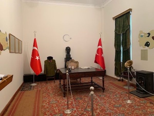
The last stop of the route is the museum of the institution that measures the sky you have been looking at all day. The Turkish State Meteorological Service gives the museum's entrance as being in Kalaba, on Kütükçü Alibey Caddesi. The museum can only be visited on weekdays during working hours, by appointment and accompanied by a guide; make your appointment in advance using the number on the institution's website. According to the institution's description, the museum was founded to show the developments in the field of meteorology in Türkiye from its foundation to the present day. Wikipedia writes that the museum belongs to the Turkish State Meteorological Service and is supervised by the Directorate of the Museum of Anatolian Civilisations. The same source presents it as one of the few meteorology museums in the world and the only museum in this field in Türkiye. The museum consists of two sections: the first displays written and visual historical documents, the second meteorological instruments and devices. The institution's page states that as of March 2003 the inventory recorded 140 instruments, devices, books, notebooks and documents. Wikipedia, for its part, writes that the second section holds more than a hundred technological instruments and devices. When touring with the guide, first follow the chronology in the documents section and then move on to the instruments. In the morning you felt the wind at Esertepe, the horizon at the tower and the shade in the garden; here you see how those same things are turned into numbers. Come with your questions ready and ask the guide which measurement each instrument was used for. The building itself carries a separate story, but here the sources do not fully agree. Wikipedia writes that the museum is in the building constructed in 1908 for the Ziraat Mektebi, the agricultural school, that the Anadolu Agency began its first work here, and that the building was used as headquarters by Atatürk and his comrades for six months. According to the same source, the museum contains an Atatürk Room preserved with his desk, coal stove and carpet. Keçiören Municipality's 2025 activity report, however, writes that the historic Çoban Mektebi building beside the Meteoroloji metro stop was restored and opened on 27 March 2024 as the Atatürk Ankara National Struggle Museum. The Wikipedia article on Keçiören also writes that the Ziraat Mektebi building, which Atatürk used as headquarters while preparing for the War of Independence, is used today by the General Directorate of Meteorological Affairs. The best course is to ask the museum, when you make your appointment, which buildings these two accounts refer to. If you have time left you can also call in at the municipal museum; the report notes that the two-storey museum tells the story of Ankara's years of the National Struggle and recreates the room with a balcony where Halide Edip and Adnan Adıvar stayed. Remember that you are on the campus of a public institution; ask the guide for permission before taking photographs. If it is close to sunset when you leave the museum, turn north and look once more at the tower you saw in the morning, as its silhouette changes when the lights come on. For the way back, take the M4 metro from Meteoroloji station; the line takes you via Dışkapı and Ulus directly to Kızılay.
Source: Meteoroloji Genel Müdürlüğü, Meteoroloji Müzesi; Wikipedia, Meteoroloji Müzesi; Keçiören Belediyesi 2025 Faaliyet Raporu.
The Meteorology Museum located in Keçiören district of Ankara is an important science museum that reflects Turkey's history and development in the field of meteorology. This building, constructed in 1908 as the Agricultural School, was also used as the headquarters of Mustafa Kemal Atatürk and his comrades during the War of Independence. Today, it serves as a museum that sheds light on both meteorology science and Turkey's recent history.
The museum consists of two main sections. The first section is the Atatürk Room, where the room where Atatürk stayed is preserved with original items reflecting the spirit of the era and presented to visitors. The second section displays old and modern devices related to meteorology, tools used for weather forecasting, various documents, and maps. Here, there are artifacts that illustrate the development of meteorology, such as old barometers, thermometers, wind measurement devices, and the first weather forecast reports.
Additionally, the museum presents the institutionalization process of meteorology in Turkey, the development of weather forecasting from the past to the present, and documents recording natural disasters to visitors. Educational activities and guided tours are also organized for students and visitors interested in weather events.
The Meteorology Museum preserves an important heritage in terms of both science and history, offering visitors a unique experience of Turkey's meteorological past. It is a place worth exploring for anyone who wants to see how weather forecasting is done and the evolution of scientific processes over time.
