


Four Ancient Cities on the Lycian Coast
Sign in to like and rate
Lycia is the old name of the region covering the Teke Peninsula west of Antalya. This route explores its eastern coast, the strip running from Olympos to Kekova, over two days, and each stop shows a different face of Lycia.
Olympos was one of the six cities that held three votes in the Lycian League. In the first century BC it became the base of the pirate leader Zenicetes, and in 78 BC the Roman commander Servilius Isauricus cleared the city of pirates and brought it under Rome. Limyra was the capital of Lycia under King Pericles in the first half of the fourth century BC, and with more than four hundred rock tombs it counts among the cities with the most rock tombs in the region. Myra was also one of the three-vote cities; in the Byzantine period it became the capital of Lycia, and today it is known for its Roman theatre and for its house-fronted tombs set side by side like a honeycomb. Simena, by contrast, was a small seaside town that joined the league through a vote shared with its neighbours, and it survives today as Kaleköy, with its castle and its sarcophagi half sunk in the sea. Three of the cities also share an old wound: the earthquake of AD 141 struck Olympos, Limyra and Myra hard, and the theatres of Limyra and Myra were repaired afterwards.
The thread that ties the route together is the rock tomb. The Lycians buried their dead in tombs cut into steep slopes, with facades imitating their wooden houses; at Limyra and Myra you will see these facades, and at Simena sarcophagi half sunk in the water along the shore. According to the Kültür Portalı, Olympos, Limyra and Myra are among the Ancient Cities of Lycian Civilization proposed in 2009 for the UNESCO World Heritage Tentative List, and the Kekova area has been on the same list since 2000.
The order follows the geography. Driving west along the coast from Antalya, the Olympos turn-off, the Finike plain, Demre and Üçağız follow one another on the same line, so nothing needs to be retraced. Olympos is reached by the turn-offs that leave the Antalya-Kumluca road towards the south, and sources put it at about 28 kilometres from Kumluca. Limyra lies in Finike district, at the Saklısu locality near Turunçova. Myra sits right on the edge of Demre, and Üçağız lies on the Kekova coast between Demre and Kaş.
Here is the plan we suggest. Give the morning of the first day to the Olympos valley and move on to Limyra in the afternoon. Spending the night in Finike or Demre district makes the second day easier. On the second day, visit Myra early in the morning, before the crowds and the heat build up. Then drive to Üçağız, leave your car there and cross to Kaleköy by boat. You can end the day in Demre or further west in Kaş district.
There are also things to keep in mind. All four stops are open air sites with little shade, so water, a hat and sturdy shoes for rocky paths are essential. The beach at Olympos is a nesting ground for sea turtles, and marked areas must not be entered during the nesting season. Swimming and diving over the sunken city at Kekova are forbidden, and boats show the ruins from a distance. Before you go, check the opening hours and entry conditions of the sites on the Müze Kart website.
Sources
- Çevre, Şehircilik ve İklim Değişikliği Bakanlığı, Kaş-Kekova Özel Çevre Koruma Bölgeleri, https://webdosya.csb.gov.tr/db/tabiat/icerikler/kekova-20211124130122.pdf
- Müze Kart (muze.gov.tr), Olympos Örenyeri, https://muze.gov.tr/muze-detay?SectionId=OLY01&DistId=OLY
- Müze Kart (muze.gov.tr), Myra Örenyeri, https://muze.gov.tr/muze-detay?SectionId=MYR01&DistId=MYR
- Kültür Portalı, Olympos, https://www.kulturportali.gov.tr/turkiye/antalya/gezilecekyer/olympos
- Kültür Portalı, Limyra Antik Kenti, https://www.kulturportali.gov.tr/turkiye/antalya/gezilecekyer/limyra
- Kültür Portalı, Myra Antik Kenti, https://www.kulturportali.gov.tr/turkiye/antalya/gezilecekyer/myra
- Kültür Portalı, Simena, https://www.kulturportali.gov.tr/turkiye/antalya/gezilecekyer/simena
- Kültür Portalı, Kekova, https://www.kulturportali.gov.tr/turkiye/antalya/gezilecekyer/kekova
- Türkiye Turizm Ansiklopedisi, Olympos, https://turkiyeturizmansiklopedisi.com/olympos
- Türkiye Turizm Ansiklopedisi, Limyra Antik Kenti, https://turkiyeturizmansiklopedisi.com/limyra-antik-kenti
- Türkiye Turizm Ansiklopedisi, Myra Antik Kenti, https://turkiyeturizmansiklopedisi.com/myra-antik-kenti
- Türkiye Turizm Ansiklopedisi, Simena Örenyeri, https://turkiyeturizmansiklopedisi.com/simena-orenyeri
- Wikipedia, Olympus (Lycia), https://en.wikipedia.org/wiki/Olympos_(Lycia)
- Wikipedia, Yanartaş, https://tr.wikipedia.org/wiki/Yanartaş
- Wikipedia, Limyra, https://en.wikipedia.org/wiki/Limyra
- Wikipedia, Mira (antik kent), https://tr.wikipedia.org/wiki/Mira_(antik_kent)
- Wikipedia, Myra, https://en.wikipedia.org/wiki/Myra
- Wikipedia, Simena, https://tr.wikipedia.org/wiki/Simena
- Wikipedia, Simena, https://en.wikipedia.org/wiki/Simena
- Wikipedia, Kekova, https://en.wikipedia.org/wiki/Kekova
- Wikipedia, Kaleköy, https://en.wikipedia.org/wiki/Kaleköy
Route Stops
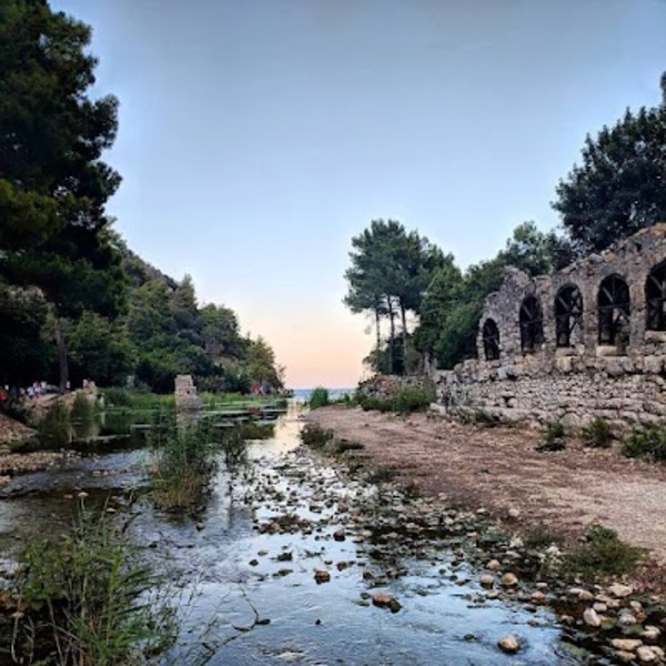
Heaven Where Nature and History Meet: Olympos Ancient City
At Olympos the site spreads through a valley, and the best way to see it is to start at the entrance and walk down along the stream to the sea. The ministry's record for the site gives its address as Yazır Mahallesi in Kumluca district; the valley opens onto the coast between Çıralı and Adrasan. Most of the remains lie under dense vegetation, so stay on the path and let your eyes wander among the trees as you walk. The city was first introduced to the scholarly world in 1812, through the records of Captain Beaufort.
The city was built on both banks of the Olympos stream, and a three-arched bridge once joined the two sides. Today one pier of that bridge can still be made out, while the quay structures on both banks still show where the harbour was. Excavations have shown that the city was laid out on a grid of right-angled streets, with North Harbour Street running east to west as its main artery. According to the excavation results, the oldest structures identified in the city are the walls of polygonal masonry that enclose the part known as the South City.
The best-known sight in the valley is the tall stone gateway left from a small temple of the Ionic order. The statue bases at the entrance show that the temple was dedicated to the Roman emperor Marcus Aurelius, and the Kültür Portalı dates the building to the years 172-173. Stand in front of the gateway and compare it with the height of someone beside it; only then does its scale become clear. On the south bank of the stream there is a small theatre, built on Hellenistic foundations and repaired in the Roman period. Another of the large buildings uncovered by excavation is the bath associated with the reign of Vespasian, and the Türkiye Turizm Ansiklopedisi dates the great bath to AD 78. The city's most crowded age, however, was the Byzantine period; according to the excavation results, in the fifth and sixth centuries the city was larger than in Roman times and the floors of its large buildings from this period were covered with mosaics.
From the first century onwards the cemeteries spread up both slopes of the valley, and the encyclopaedia records that 354 tombs have been identified here. Necropolis Street in the northern city is an interesting lane, because in the Byzantine period its Roman tombs were used as dwellings and civil buildings were added between them. The Kültür Portalı considers the sarcophagus of Captain Eudemos, set in a rock hollow near the river mouth and known for its ship relief and verse inscription, the most interesting remain in the city. The Türkiye Turizm Ansiklopedisi, however, says the piece is in the Antalya Museum, so ask the site attendant whether you can see it in place. The encyclopaedia also mentions the remains of two castles in the southern and northern parts of the city; look up at the slopes as you approach the beach.
When you reach the beach, remember the city's pirate past. In the first century BC the city was the base of Zenicetes, the Roman commander Servilius laid siege to it, and rather than surrender Zenicetes burned himself together with his family. After this defeat Olympos was expelled from the Lycian League and was only readmitted in the first century AD. This beach is also one of the places where loggerhead turtles lay their eggs; between May and September volunteers watch over the protected areas, so keep away from marked nests. Cooling off on this coast, known for its clear water, is the best way to end three hours of walking.
If you still have time in the evening, stop at Yanartaş on the Çıralı side. The flames are on the southern slope of Çakaltepe; according to Wikipedia, they rise from cracks in the rocks at about 180 metres above sea level and are fed by a natural gas that is mostly methane. The Türkiye Turizm Ansiklopedisi explains that this gas, compressed by earthquakes, reaches the surface at the same spot. According to the Kültür Portalı, Olympos was famous in antiquity for this self-burning fire, and the flames are linked with the fire-breathing Chimaera of legend. The flames are best seen in the dark, but since you will be climbing a slope, bring a torch and sturdy shoes. After Olympos, return to the Antalya-Kumluca road and head west towards the Finike plain; the next stop is Limyra.
Source: Müze Kart (Olympos Örenyeri); Kültür Portalı; Türkiye Turizm Ansiklopedisi; Wikipedia (Olympus, Lycia); Wikipedia (Yanartaş).
Located in the Kumluca district of Antalya, Olympos is one of the most special spots in the Mediterranean with its historical ruins and enchanting nature. Olympos, one of the important cities of the Lycian League, has witnessed pirate attacks, as well as the Roman and Byzantine periods since the 2nd century BC, carrying its mystical atmosphere to the present day.
The ancient city captivates its visitors with its ruins hidden between pine forests and the sea. Among the most striking structures of Olympos are the Ancient Theatre, temple ruins, tomb monuments, and Roman bath. The Olympos River, which runs through the city, served as a port in ancient times.
One of the most special spots in Olympos is Yanartaş (Chimera). The flames that have never gone out for centuries due to natural gas leaking from the slope are described in mythology as the breath of the legendary creature Chimera.
Today, Olympos is an ideal destination for nature and adventure lovers with its extraordinary tree houses, beach, trekking, and rock climbing opportunities. If you want to explore historical and natural beauties together, Olympos Ancient City should definitely be on your list! 🏛🌿🔥
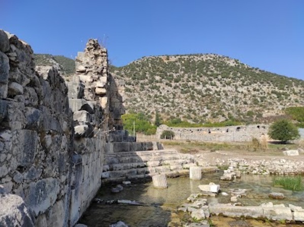
The Mysterious City of Lycia: The Ancient City of Limyra
Limyra spreads over the southern foot of Toçak Mountain and the plain in front of it, at the Saklısu locality near Turunçova in Finike district. The city has two levels: the acropolis, or Upper City, on the mountain, and on the plain the Lower City, divided into a West City and an East City. To make good use of two hours, look at the theatre first, then move on to the remains on the plain, and leave the climb to the acropolis for last.
The city's Lycian name is Zemuri, and settlement here is known to go back at least to the fifth century BC. Limyra lived its brightest period in the first half of the fourth century BC, when King Pericles made it the capital of Lycia and supported the satraps who rose against the Persians. After him the region came under Persian control again, and the Carian satrap Mausolus played a part in this. Today the theatre is regarded as the symbol of the city. The Kültür Portalı and the Türkiye Turizm Ansiklopedisi write that it was built in the Hellenistic period and repaired after being badly damaged in the earthquake of AD 141. English Wikipedia, on the other hand, attributes the Roman theatre to the Lycian benefactor Opramoas in the second century AD and says it held 8,000 spectators. Because the theatre is cut into the slope, you get a good view of the plain from the upper rows.
Limyra is one of the cities with the most rock tombs in Lycia. The Kültür Portalı speaks of more than four hundred rock tombs, most of them known through their inscriptions in the Lycian language. According to the Türkiye Turizm Ansiklopedisi, 200 rock tombs and sarcophagi stand together in the second necropolis on the slope of Toçak Mountain. As you look at the facades, notice how wooden house architecture was translated into stone; you will see the same tradition more closely at the next stop, Myra.
When you come down to the plain, start with the West City. Here lie the foundations of the Ptolemaion, a monument dated to the first quarter of the third century BC, in the reign of Ptolemy II. According to English Wikipedia, the people of Limyra raised it in gratitude to Ptolemy II Philadelphus, who had supported the city against the invading Galatians. The walls of the West City were strengthened with 11 towers against the Arab raids in the seventh century AD. A road that leaves through a gate in the same area and descends through marshy ground leads to the cenotaph of Gaius Caesar, a monumental tomb that holds no body. Gaius Caesar, presented as the heir of Augustus, died at Limyra in AD 4 on his way back to Rome from wounds received in Armenia. In the East City there are the Roman North Bath and South Bath and the remains of the bishop's palace from the Byzantine period. The city was a bishopric in the Byzantine period and was abandoned after the Arab raids of the eighth and ninth centuries.
Notice the water around the Lower City as well. According to the Türkiye Turizm Ansiklopedisi, the Limyros stream, today's Göksu, fed by the karstic Saklısu spring at the foot of Toçak Mountain, surrounds the islet on which the city stands. The Roman bridge east of the city now lies largely under the alluvium of the plain, and English Wikipedia counts it among the oldest segmental arch bridges in the world.
The acropolis is a fortress that King Pericles had built at a height of about 315 metres, strengthened with towers and battlements. Here stands the Heroon of Pericles, dated to the fourth century BC, whose facade has female statues, the caryatids, in place of columns. Some of the reliefs and caryatids of the heroon are displayed in the Antalya Museum, so look for the original pieces there as well. Going up to the acropolis means a climb along the slope; do not go in the hot hours and take water with you.
Excavations have been carried out in the city since 1969; in the early years German and since 1982 Austrian archaeological institutes have supported the work. Check the current visiting conditions of the site with official sources before you go. After Limyra, continue west through Finike to Demre; spending the night in Finike or Demre and leaving Myra for the next morning is the most comfortable plan.
Source: Kültür Portalı (Limyra); Türkiye Turizm Ansiklopedisi; Wikipedia (Limyra).
Located in the Finike district of Antalya, Limyra Ancient City is one of the oldest and most important cities of the Lycian civilization. With a history dating back to the 5th century BC, Limyra has been a significant center both politically and culturally.
In the ancient city, there are remarkable structures such as Lycian rock tombs, a theater, an agora, and monumental sarcophagi. Especially, The Tomb of King Pericles is one of the finest examples of Lycian art. Additionally, the Roman Bridge is one of the ancient engineering marvels that has remained intact to this day.
Today, Limyra, which can be explored in a nature-integrated environment, is a fascinating discovery point for history and archaeology enthusiasts.
Myra Ancient City.
Myra lies at the foot of a rocky slope on the edge of Demre, looking over the alluvial plain formed by the soil carried by the Demre stream, the ancient Myros. According to the Türkiye Turizm Ansiklopedisi, because of this alluvium the ancient city now lies about five kilometres inland from the sea. Most of the remains of the Lycian and Roman towns also lie under this soil; what you can see is the theatre set against the slope and the tombs carved into the rock. To make good use of ninety minutes, visit the theatre first, then the rock tombs just above it, and use the remaining time for the second necropolis to the east.
Myra, whose name appears in Lycian inscriptions, was one of the six large cities that held three votes in the Lycian League, and Strabo counts it among the largest cities of the league. When Lycia became a separate Roman province in AD 325, Myra became its capital. The best-known building from this importance in the Byzantine age is the Church of Saint Nicholas in the town centre; this route, however, is devoted to the theatre and the rock tombs. Arab raids weakened the city between the seventh and ninth centuries, and in 809 Myra was taken by an Abbasid army.
The theatre was built on the southern foot of the acropolis. The ministry's page for the site describes it as a structure set against the rock tombs above it and extending downwards, and counts it among the few ancient theatres that have survived to the present day. According to the Türkiye Turizm Ansiklopedisi, the theatre, with room for 11,000 people, is one of the largest in Lycia. The building was destroyed in the earthquake of AD 141 and rebuilt afterwards. Look for theatre masks carved in stone around the stage building; such masks were found in the excavations, and the encyclopaedia also mentions a mask frieze, statues and seats with backrests. The seats of honour in the front rows are said to carry depictions of fish and animals, so look closely at the lower rows. Since the theatre and the rock tombs share the same slope, you can see both in a single frame.
One group of the city's rock tombs is in the cliff just above the theatre and is known as the Sea Necropolis. The Türkiye Turizm Ansiklopedisi describes the tombs here as monuments lined up side by side like a honeycomb, imitating typical Lycian houses. The tombs are carved into the sheer rock face; some have house-shaped facades, others temple-front facades. The ministry's page especially stresses that the reliefs on the tombs are remarkable. The encyclopaedia says it counts a total of 104 rock tombs in three separate areas at Myra, while Wikipedia speaks of two large necropolises. Do not climb the rocks or touch the reliefs; watch the facades from the visitor area below.
The second large group is the River Necropolis, about 1.5 kilometres upstream along the Demre stream. According to the encyclopaedia there are 41 rock tombs here, and the most famous is known as the Painted Tomb. It is said that eleven life-size figures are carved in relief on this tomb. When the traveller Charles Fellows saw the tombs in 1840, he noted that red, yellow and blue paint could still be made out on them.
Systematic excavations at Myra began in 2009 under the direction of the archaeologist Nevzat Çevik. Check the current visiting hours of the site on the Müze Kart website before you go. If you have time, you can also stop at Andriake, the ancient harbour about five kilometres away, where the granary built in the reign of Emperor Hadrian is now used as the Museum of Lycian Civilizations. After Myra, drive on towards Kaş and go down to Üçağız on the Kekova coast; you will leave the car there and cross to Kaleköy by boat.
Source: Müze Kart (Myra Örenyeri); Kültür Portalı (Myra); Türkiye Turizm Ansiklopedisi; Wikipedia (Mira); Wikipedia (Myra).

Simena (also known as Kaleköy)
Simena is known today as Kaleköy and lies in Demre district, on a small peninsula opposite Kekova Island. There is no road to the village; you leave your car in Üçağız and cross by boat, and sources say it can also be reached on foot from Üçağız. Üçağız itself stands on the site of ancient Teimiussa, and the two villages are only about a kilometre apart. When you arrange your boat, say at the outset that you also want to see the sunken city shore and that you need enough time at Kaleköy to climb to the castle.
According to the sources, settlement at Simena goes back to the fourth century BC, as grave inscriptions and coin finds show. The city's name first appears in the first century AD in the work of the Roman writer Pliny. Simena did not join the Lycian League on its own but as part of a union of towns it formed with Aperlae, Isinda and Apollonia, and this group cast a single vote together.
After the pier, walk uphill through the village to the castle. English Wikipedia describes the castle as an East Roman fortress built in the Middle Ages against the pirates who nested in Kekova. Turkish Wikipedia adds that remains of Hellenistic walls and of the Byzantine castle stand side by side here. The first structure you see on reaching the castle is a small theatre carved into the rock, with seven rows of seats and room for about three hundred people. Some sources also note that the structure may be either a theatre or a council house, a bouleuterion. The town also has cisterns that were used to supply water to ships. From beside the walls, look out towards Kekova Island and the narrow channel between; from here it is easy to understand why this sheltered coast was a refuge for ships and pirates alike. The way up is steep, so take your time in the hot hours and carry water.
On the way down, look at the tombs. Kaleköy lies in the middle of a Lycian necropolis, part of which is under water, and some of the rock tombs carry Lycian inscriptions. According to the Kültür Portalı, Lycian-type sarcophagi can be seen both in various parts of the castle and along the shore, in the water. The inscription on one of them says that the sarcophagus belonged to Mentor, son of Idargus. You see the shore sarcophagi best from a boat, with their bodies rising out of the water.
The sunken city shore is the last part of the route. According to the Kültür Portalı, the town was partly submerged because of earthquakes in antiquity. The remains of a Roman bath stand in the water along the shore; Turkish Wikipedia dates the building to the second half of the first century AD, while an English source calls it the baths of Titus. The Türkiye Turizm Ansiklopedisi also mentions submerged roads and small islets that were used as quarries. Turkish Wikipedia writes that the submerged harbour mole and ruins can be clearly made out at a depth of about one metre. Most of the ruins known as the sunken city, however, lie on the northern shore of Kekova Island opposite, and English Wikipedia identifies them as the town of Dolichiste, destroyed by an earthquake in the second century.
Simena is a first-degree archaeological site and lies within the Kekova Specially Protected Area, which covers 260 square kilometres. The area was declared a special environmental protection area in 1990, and the Ministry states that diving is forbidden in some coves because of the archaeological remains. Check the swimming and diving rules before you go, and watch the sunken remains from the boat. At the end of the day, return to Üçağız by boat; the route ends here, and you can spend the night in Demre or further west in Kaş district.
Source: Kültür Portalı (Simena, Kekova); Çevre, Şehircilik ve İklim Değişikliği Bakanlığı (Kaş-Kekova ÖÇK); Türkiye Turizm Ansiklopedisi; Wikipedia (Simena); Wikipedia (Simena, Kaleköy, Kekova).
